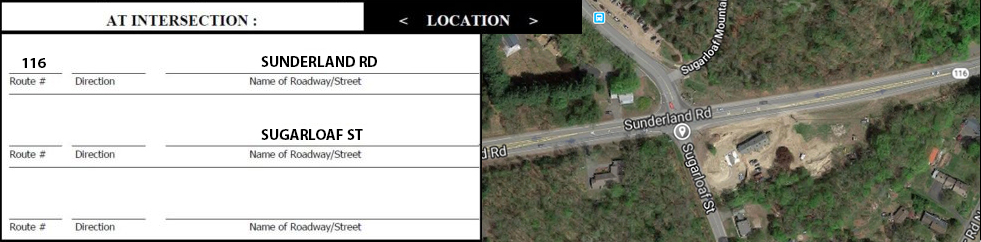
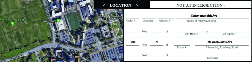
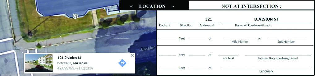
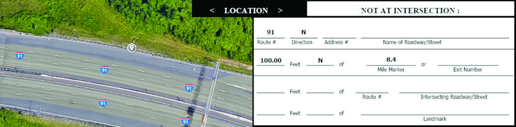
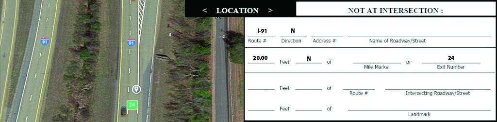
Location Methods

Crash location can be documented using five primary methods:  Intersection, Off-Intersection, Address, Mile Marker or Exit. Additionally, landmarks may be used to supplement the primary methods.

When completing the location section, choose the method that will best represent the crash location. Please keep in mind that these crashes are automatically geolocated, and while diagram/narrative/landmark information is useful for other applications, they are not used in automation.

It is essential to submit proper crash locations, as MassDOT (and many other organizations) use this information to develop projects and programs for improving safety in the Commonwealth. In order to do this, each officer should try to pinpoint this location.

  • Use AT INTERSECTION method if the crash occurred within 30 feet of an intersection of two or more public roadways/streets.
  • Use a NOT AT INTERSECTION method if the crash occurred more than 30 feet from an intersection.


It is crucial to complete the location section as detailed as possible. Funding and roadway improvements are determined based on data that can be mapped to an exact location.

Car crash on a street with fire trucks police reporting

Required Fields

  • Name of Roadway and/or Route Number
  • Direction of Roadway/Route
  • Name of Intersecting Roadway and/or Route Number
  • Direction of Intersecting Roadway/Route

Guidelines

  • Use AT INTERSECTION method if the crash occurred within 30 feet of an intersection of two or more public roadways/streets.
  • Identify roadways by both the roads’ names and the route numbers (if applicable).
  • If there is a roadway that intersects with another roadway multiple times within a city/town, please identify any other intersecting streets to help accurately pinpoint the crash location.
  • Place names (such as corner names, squares, etc.) that are known only to local residents may be used as landmarks, but not in lieu of the correct street names.
  • Please identify any landmarks by street address (i.e. Dunkin Donuts at 123 Main St.).

Example

Crash Data Audit Results

A statewide 2017 Crash Data Audit found the Intersection Method to be the location method with the highest percentage of crashes that could be adequately geolocated (81 percent). The rates of successful geolocation were much higher for local police than State Police. However, State Police rarely used this location method. The Direction was often missing on reports using the Intersection Method.  The Narrative and/or Diagram, while useful for a multitude of other applications, cannot be used for automatic geolocating of crashes.

The common inconsistency on local police reports was whether the crash occurred in an intersection or in close proximity to an intersection.

Required Fields

Use the Not at Intersection Method and include these fields:

  • Name of Roadway/Street
  • Intersecting Roadway/Street
  • Distances from Intersecting Roadway/Street
  • Direction from Intersecting Roadway/Street

Guidelines

  • Use the Off-Intersection Method if the crash occurred in proximity to an intersection but GREATER THAN 30 feet away.
  • When reporting crash locations as a distance from the nearest intersecting roadway, estimates of distances are preferred to no distance at all.
  • Identify roadways by both the names of the roads and, if applicable, the route numbers.
  • If there is a roadway that intersects with another roadway multiple times within a city/town, please add a landmark or an address as well.

Example

Example for Off Intersection location method

Crash Data Audit Results

The common error found in the 2017 Crash Data Audit was the use of the At-Intersection Method when the crash occurred greater than 30 feet away from the intersection.

Required Fields

  • Name of Roadway and/or Route Number
  • Direction
  • Address #

Guidelines

  • Identify not only the roadway/street where the crash occurred, but also the nearest address number so the crash location can be pinpointed.
  • Identify roadway by the name of the road instead of the route number.
  • While place names (such as corner names, squares, etc.) that are known only to local residents should not be relied on to document location, these may be used to supplement an address as a landmark.
  • Please identify any landmarks by street address (i.e. Dunkin Donuts at 123 Main St.).

Example

Crash Data Audit Results

In the statewide 2017 Crash Data Audit, the Address Method was used effectively by local police, meaning the crashes were able to be geolocated 78 percent of the time. State Police rarely used this location method while Local Police used it often. In the few cases where State Police did use the Address Method, auditors often indicated that the Off-Intersection Method may have been more appropriate.

The Narrative and/or Diagram provided supplemental information used to locate the crash 38 percent of the time in cases where manual geolocation was necessary.

Required Fields

  • Route #
  • Direction
  • Mile Marker
  • Distance from Mile Marker
  • Direction from Mile Marker

Guidelines

  • Identify not only the roadway/street where the crash occurred, but also the nearest mile marker, as well as the distance and direction from that mile marker.
  • Identify roadway by both the route number and name of the road (if applicable).
  • When reporting crashes on numbered routes, please use mile markers whenever possible. Do not use utility pole numbers as a landmark in place of a mile marker.
  • Do not simply use whole numbered mile markers. Include the decimal (see example below) so that the location of the crash can be most accurately located.

Example

Crash Data Audit Results

In the statewide 2017 Crash Data Audit, the Mile Marker Method of locating a crash was only used by State Police. Distance information was commonly missing from the Mile Marker field, making it difficult to determine the precise location of the crash. Furthermore, the Mile Marker Method had the lowest percentage (22 percent) of reports containing additional information in the Narrative and/or Diagram that would help in crash geolocation.

The vast majority of reports using the Mile Market Method (over 95%) simply used a whole-number Mile Marker instead of indicating the decimal point. While the distance between mile markers is significant (.2 miles or 1056 feet), it is extremely helpful to use the exact number.

Required Fields

  • Route #
  • Direction
  • Exit Number
  • Distance from Exit Number
  • Direction from Exit Number

Guidelines

  • When crashes are located by exit number it is located to the point where the exit ramp diverges from the mainline. If the crash occurred on the ramp itself or at the ramp terminal, other location information should be used instead of exit number.
  • Identify roadway by the route number instead of roadway name.
  • If a crash did not occur on the ramp itself, the distance and direction from the ramp should be indicated, otherwise the crash would be geolocated as a ramp crash.

Example

Crash Data Audit Results

The statewide 2017 Crash Data Audit found the Exit Ramp Method to be used only by State Police, with less than 28 percent of reports within the sample having adequate information to geolocate the crash. Additionally, the Route Direction of the roadway (connected to the ramp) was provided on only 49 percent of the reports reviewed. Another issue with this location method was that the Distance of the crash location from the exit ramp was only provided on about 5 percent of reports. Furthermore, only 31 percent of the reports audited in this sample had additional information in the Narrative and/or Diagram.